
 By Despoina Pavlaki
ATHENS NEWS 03/05/2010, page: 24-25
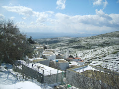
FEATURING the largest network of hiking trails in the Cyclades, the island of Tinos is simply aching to be walked - but visitors are still dragging their feet.
Split down the middle by its adherents to either the Catholic or Orthodox faith and strewn with intricate pigeon lofts that may appear quaint but in fact attest to the island’s past idiosyncratic eating habits, Tinos largely remains a mystery. And the best way to explore it is still on foot.
The island is sandwiched between Syros and Andros, two Aegean destinations with their own trail mystique, but neither can claim a network so extensive. All that’s required is monster stamina.
“In the olden days, walking a trail was probably considered relaxing,” says Karolos Merlin, a trekking guide and Tinos devotee, “At least compared to digging soil all day, which is what most people did for a living. It was a tough life.”
Boasting the largest population in the Cyclades - during Venetian rule, there were 35,000 residents - the island’s agricultural tradition remained unrivalled.
Less nautically inclined than Andros and much more densely constructed than Syros, Tinos was the most labour-intensive lump in the Aegean Sea - which is what multiplied the number of trails in the first place.
The need for each and every farmer to reach his life-supporting piece of land was so crucial that the island soon became a web of more trails than residents had veins in their hands.
Waterlogged
Paths were carved wisely. Larger cobblestoned tracks usually connected one village to the next, where smaller dirt roads led to private properties. Their common denominator was a surprising sensibility towards recycling rainwater (channelling pluvial water was key) and the ability to take you anywhere you wanted to go in the shortest amount of time.
Aside from highlighting the significance of a certain route, cobbling was sometimes necessary to prevent mudslides, as the now largely parched island of Tinos used to be a lot rainier.
“In order to preserve the trails, communities assigned each member a chore,” says architect Ioanna Papastathopoulou, who specialises in the management of cultural heritage. “It was something like voluntary labour in order to maintain the trail in good condition.”
After the Second World War, what with the Americans flooding the market with cheap flour and grains, islanders began to lose their footing in the European markets and started seeking a better fortune in the big cities.
Agricultural life, as they knew it, was over. The waves of mass migration threatened to sweep the island clean of its once numerous inhabitants - and their walking habits went with them. The trails were suddenly abandoned.
Changing times
The rougher, northernmost villages were the first to go into decline. As the climate changed, the island became draughtier, and those left behind had a much harder time working the land, which meant areas with limited access to water were soon to be deserted.
What was once resplendent with greenery - at least according to an anonymous 19th-century travel writer - was slowly turning into dried land.
“Most of the trees you see now are the products of abandoned orchards gone wild,” says Merlin, although there are traces of an ancient forest. The so-called fides, a local variety of wild cypress, is evident in the architecture, as the tree’s crooked bark was immune to woodworm and was often used in the construction of ceilings.
Those residences, along with anything built before the 1830s, are automatically considered cultural monuments, including the entire path network.
Too bad the local Ephorate of Prehistoric and Classical Antiquities can’t do very much to protect them. But in a country brimming with archaeological priorities, that would indeed be a tall order. The only way to rescue what was left was to involve locals.
“The mobilisation of the prefecture and the municipalities was relatively recent,” says Papastathopoulou, who is also in charge of a volunteer path-clearing programme set to kick off in mid-June.
“The trails suffered devastating damage because they basically facilitated illegal roads. Instead of starting fresh, you could simply widen an already existing trail and, lo and behold, it was suddenly a motorway. The need to protect and showcase them only arose from acute destruction.”
Walk the talk
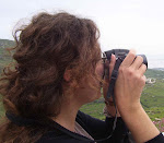
TREKKING guide and trail-map wizard Karolos Merlin (photo) explains why pigeon loft island - also known as Tinos - is the best kept hiking secret in the country.
Born in Austria and raised in Greece, Merlin started out as a graphic artist but his undying love of mountains grew parallel with his design aesthetics. And eventually won out.
“I’ve been a trekking guide for 15 years now. I work in different parts of Greece but I focused my professional activities on the Cyclades. Tinos is my second home.”
With a bit of time on his hands and a newfound friend in his GPS, a contraption he hadn’t used before, he started mapping. He decided to record the island’s intricate network of paths, a feature that set it apart from the rest of the Cyclades.
“Each island is unique. Andros, for example, was more nautical than agricultural. It also had fewer villages, which made the need for an extended trail system redundant,” Merlin explains. “Syros, on the other hand, is smaller and the paths are fewer but very well preserved. If it connects two large residential areas, it makes sense to still use it.”
Sad but true
Being the agricultural hub that it once was, Tinos required an extensive network of paths. When a large percentage of the population moved away to Athens, the trails deteriorated, a fact mourned by those left behind.
A state effort to preserve Tinos’ heritage of paths was initially limited to installing signs and clearing tracks - a task doomed to fail if not frequently repeated.
Unless, of course, walking tourism would rise to the desired levels - 10,000 visitors a year - and the problem took care of itself because there’s nothing better for maintaining an overgrown trail than a healthy volume of pedestrian traffic.
When it comes to Tinos, most trails are marked with dry stone walls as the entire natural landscape was covered in terrace cultivation, a method of growing crops on mountainsides by planting on graduated terraces built into the slope.
“Width depended on importance,” Merlin says. “Less significant trails connecting isolated properties were about 1-1.2m wide. Frequently used intersections could add half a metre more, and central ancient trails could be 4-5m wide.”
If you visit the island and decide to take a walk on the wild side, watch out for the appropriate signage. Blue and red dots are usually painted by private citizens, while municipality or prefecture officials mark their paths with numbered signs. Trail categories are hard to define, as the local network isn’t what is used to be.
As Merlin explains: “There weren’t as many different kinds 150 years ago as there are now. They were either cobbled or plain dirt, and if the terrain was too steep, steps would often be chiselled into the rock to make passage less slippery. Nowadays, a lot of the paths have been reduced to goat trails.”
Road warriors
But they’re not the ones that have done the damage. The landscape keeps changing as prospective holiday homeowners carve out new roads, constantly forcing Merlin to revise his maps. The one he published three years ago, with the Anavasi maps and navigation firm, is already in need of major alterations.
“I had documented a 220km trail network at the time. I’ve now reached 320km and counting, but it’s a race against time. As soon as I discover one trail, they destroy another,” he says. “They usually do it in the winter and mostly at night time when no one is watching. Everybody wants a holiday home but nobody wants to walk there. The thing is, the distance between a trail and a main road is no more than 100-300m.”
Merlin is currently in close collaboration with the authorities in an effort to proclaim 12 routes national cultural heritage. The only problem is walking tourism is simply not growing fast enough.
“No matter how much money is spent on preservation, the investment will only yield results when we reach 10,000 hikers a year,” he says. “And right now we’re at 3,000 - tops. All I want is for people to come over and walk the trails. I don’t care if they contract my services or not.”
• Karolos Merlin may be reached via www.tinos-island.info, offering information to anyone and everyone who wants to explore the island. The routes he has documented are available for download on GPS via Wikiloc.com and Google Earth
Beyond cliches
AWAITING her impending move to the island of Tinos, Ioanna Papastathopoulou (photo), an architect specialising in cultural heritage, is prepping for a summer workshop organised by Elix, a non-governmental organisation.
It’s the fourth time Elix will visit the island, bringing with it foreign volunteers involved in programmes promoting environmental protection and cultural heritage.
This year they’re on a cleaning mission, focused on six different trails, three of which are sponsored by the prefecture and three by the municipality of Exombourgo.
Their trails of choice will be cleaned by six teams from mid-June to the end of September, rotating every two weeks. Participating teams will be coordinated by appointed team leaders, plus a craftsman assigned by the municipal authorities.
The volunteers will be removing any overgrowth and helping reconstruct sections of collapsed stone walls.
“The government really needs to use the Greek National Tourism Organisation to promote walking tours, showcasing Tinos as the ultimate hiking destination,” says Papastathopoulou, whose maternal grandmother was born on the island and who has been an active member of the local community for the past couple of years.
“People are so hung up on this image of the Cyclades with the little whitewashed houses and the endless beaches that no one bothers to look any further. It’s about time they opened their eyes.”
• For more information, see www.elix.org.gr
A guide to surviving your first walking experience
• Always use a stick (baton, or other) for good balance and remember to beat the rocks as you walk. The sounds scares away the snakes, which are plentiful but not necessarily dangerous in spring and summer
• Always carry a cellphone with charged batteries
• Make sure you bring a GPS if you have no prior knowledge of the track - or at least a good map
• Don’t forget to fill your water bottle
• Hiking boots and heavy pants are absolutely necessary to protect your ankles and legs
• The good news is most Tinos trails are located near main roads or villages in case you get lost. The bad news is explaining your exact location is very difficult
• Best start out with a 2-3 people party in case of an accident
• Some of the tracks have been covered with soil and you might need to walk on the dry stone walls. Though they are quite sturdy, you need to feel for the occasional loose stone before you proceed.
• Even if the trail is overgrown the dry stone walls will show you the way
• And remember: Tinos on foot holds many secret pleasures you’d totally miss out on if holed up in a car.


.jpg)


Δεν υπάρχουν σχόλια:
Δημοσίευση σχολίου